Elephant Rock, a monumental natural sandstone formation in AlUla, one of Saudi Arabia's most beautiful tourist attractions Nabatean tombs carved into sandstone at Hegra, AlUla, Saudi Arabia Misty green peaks of the Asir Mountains near Abha, Saudi Arabia

Discover the Best of Saudi Arabia

Explore breathtaking landscapes, ancient heritage, vibrant cities and hidden gems across the Kingdom — with exact locations, nearest cities, nearest airports and entry fees for every stop.

Explore Places
Natural WondersMountains, deserts, coasts & more
Historic SitesHeritage, landmarks & ancient cities
Vibrant CitiesModern life, culture & experiences
Hidden GemsUnique places off the beaten path

Explore by Category

Find what you're most interested in

Explore Saudi Regions

Each region has its own unique story

Tabuk AlUla Madinah Riyadh Makkah Asir Eastern Province Jazan
Riyadh RegionModern cities & heritage
Tabuk RegionDeserts & ancient sites
Makkah RegionHoly sites & mountains
Eastern ProvinceCoasts & modern cities
Madinah RegionHistory & spirituality
AlUla / Al MadinahHeritage & archaeology
Asir RegionMountains & nature
Jazan RegionRed Sea islands
Explore All Regions
Jubbah rock art, a hidden gem in Saudi Arabia

Hidden Gems

Beyond the famous landmarks — discover beautiful places that many travelers haven't explored yet, like Jubbah's 10,000-year-old petroglyphs and the Al-Ahsa Oasis.

Explore Hidden Gems →
Al-Ahsa Oasis, a hidden gem in Saudi Arabia

Al-Ahsa Oasis

The world's largest self-contained oasis and the wind-cooled caves of Al-Qarah Mountain — a UNESCO site most visitors never make it to.

See Al-Ahsa →

Travel Guide

Everything you need to know before you go

Best Time to Visit
Weather
What to Wear
Local Customs
Transportation
Travel Tips
Safety Info
View Full Travel Guide

Why Visit Saudi Arabia?

A land of timeless heritage, breathtaking nature, modern cities and warm hospitality.

Rich Heritage
Diverse Landscapes
Vibrant Culture
Warm People

Frequently Asked Questions

Common questions about planning a trip to Saudi Arabia

What are the top places to visit in Saudi Arabia?

Top highlights include Hegra in AlUla, At-Turaif in Diriyah, Historic Jeddah's Al-Balad quarter, Masmak Fortress and the National Museum in Riyadh, the Edge of the World, the Asir Mountains, Al-Ahsa Oasis, Al Wahbah Crater, Jubbah's rock art, Umluj's beaches and the Farasan Islands.

What is the best time to visit Saudi Arabia?

October through April offers the most comfortable weather for sightseeing and desert trips. Mountain regions like Asir and Al-Baha stay mild even in summer.

Do tourists need a visa to visit Saudi Arabia?

Many nationalities can apply for an e-visa or visa-on-arrival. Requirements vary, so check the official Saudi e-visa portal or your nearest embassy before booking.

Is Saudi Arabia safe and open for tourism?

Saudi Arabia has actively opened to international leisure travel since 2019 under Vision 2030, with new tourist visas, airports and restored heritage sites across the Kingdom.

Which attractions are UNESCO World Heritage Sites?

Hegra (AlUla), At-Turaif (Diriyah), Historic Jeddah's Al-Balad, Al-Ahsa Oasis, and the Hail Region rock art sites including Jubbah are all UNESCO-listed.

Which attractions are free to visit?

Masmak Fortress, the National Museum, Al-Balad, the Edge of the World, Al Soudah, Al-Ahsa Oasis, Al Wahbah Crater, Jubbah, Umluj and Al Baha are all free — though some activities within them are ticketed.

Stay Inspired

Get the latest travel stories, hidden gems and updates about Saudi Arabia.

Full Destination Details

Every attraction, broken down

Location, general information, nearest big city, nearest airport and entry fees for all 15 destinations above.

  1. Hegra, AlUla UNESCO · Paid
  2. At-Turaif, Diriyah UNESCO · Paid
  3. Masmak Fortress Riyadh · Free
  4. Al-Balad, Jeddah UNESCO · Free
  5. Edge of the World Riyadh · Free
  6. Rijal Almaa Asir · Paid
  7. Al Soudah Asir · Free
  8. Farasan Islands Jazan · Free
  9. Al-Ahsa Oasis UNESCO · Free
  10. Al Wahbah Crater Taif · Free
  11. Jubbah Rock Art UNESCO · Free
  12. Umluj Beaches Tabuk · Free
  13. National Museum Riyadh · Free
  14. Al Baha Mountains Al-Baha · Free
  15. Honey Refinery Asir · Paid
Medina Province · Northwest Arabia

Hegra (Mada'in Saleh)

Saudi Arabia's first UNESCO World Heritage Site
Aerial view of AlUla oasis town near Hegra archaeological site, Saudi Arabia Nabatean tombs carved into sandstone at Jabal al-Ahmar necropolis, Hegra, Saudi Arabia Restored mudbrick lanes of Al-Ula Old Town near the Hegra site, Saudi Arabia
AlUla oasis and the Nabatean tombs of Hegra

Carved by the Nabataeans — the same civilization behind Jordan's Petra — Hegra holds more than 110 monumental tombs cut directly into free-standing sandstone outcrops, some rising over 16 metres tall and dated to the 1st century BCE. It was inscribed as Saudi Arabia's first UNESCO World Heritage Site in 2008, and remains the best-preserved Nabataean city south of Petra itself.

Entry is by timed ticket only, usually bundled with a guided tour that also covers the restored Old Town of AlUla and the Hejaz Railway station. Visit between October and March; the desert heat makes summer visits punishing and many facilities scale back.

UNESCO World Heritage Nabatean Tombs Desert Archaeology AlUla Tourism
Hegra at a glance
Location
AlUla Governorate, Medina Province — northwestern Hejaz region
General info
111+ rock-cut Nabatean tombs across four necropolises, 1st c. BCE–1st c. CE
Nearest big city
AlUla town (25 km); Medina (~300 km)
Nearest airport
AlUla International Airport (ULH), ~25 km away
Riyadh Province · Central Arabia

At-Turaif District, Diriyah

Birthplace of the first Saudi state

Perched above the green ribbon of Wadi Hanifa, At-Turaif was the capital of the First Saudi State from 1727 until 1818 and the original seat of the House of Saud. Its dense cluster of mudbrick towers and courtyards is the finest surviving example of Najdi architecture anywhere, which earned it UNESCO World Heritage status in 2010.

The district has been meticulously restored as the centerpiece of the wider Diriyah Gate development, now ringed with museums, cafés and galleries. Sunset is the best time to walk the ramparts, when the clay walls turn the colour of the desert around them.

UNESCO World Heritage Najdi Architecture Riyadh Day Trip Saudi History
Restored mudbrick towers of At-Turaif District in Diriyah, Saudi Arabia's first UNESCO World Heritage Site Najdi mudbrick architecture and courtyards of At-Turaif District, Diriyah, Saudi Arabia Restored ramparts and towers of At-Turaif District overlooking Wadi Hanifa, Diriyah
Restored Najdi mudbrick towers of At-Turaif
At-Turaif at a glance
Location
Diriyah, on the edge of Wadi Hanifa, Riyadh Province
General info
Capital of the First Saudi State (1727–1818); UNESCO-listed 2010
Nearest big city
Riyadh, roughly 20 km south
Nearest airport
King Khalid International Airport (RUH)
Riyadh Province · Ad-Dirah District

Masmak Fortress

Where the modern Kingdom began
Masmak Fortress clay and mudbrick citadel in old Riyadh, Saudi Arabia, site of the 1902 battle for the city Entrance and mudbrick walls of Masmak Fortress in central Riyadh, Saudi Arabia Masmak Fortress illuminated at night in old Riyadh, Saudi Arabia
Masmak Fortress, old Riyadh

This squat clay-and-mudbrick citadel in the heart of old Riyadh is where a young Abdulaziz Al Saud, in a daring 1902 night raid with sixty-odd men, recaptured the city and set the unification of Saudi Arabia in motion. The original wooden door still carries the mark of a spearhead thrown during the battle.

Today it functions as a compact, free museum with weapons, photographs and dioramas telling the story of the Kingdom's founding — an easy, unhurried hour that pairs naturally with the nearby Souq Al Zal antiques market.

Free Museum Old Riyadh Saudi Unification History Najdi Fort
Masmak Fortress at a glance
Location
Ad-Dirah district, central old Riyadh
General info
Built 1865; site of the pivotal 1902 Battle of Riyadh; museum since 1995
Nearest big city
Riyadh — located in the city centre
Nearest airport
King Khalid International Airport (RUH), ~35 km
Entry
Free admission
Makkah Province · Red Sea Coast

Al-Balad, Historic Jeddah

The old gate to Mecca

Al-Balad is Jeddah's original walled town, a labyrinth of coral-stone merchant houses with elaborately carved wooden mashrabiya screens that once cooled sea breezes for Red Sea trading families. For centuries it was the arrival point for pilgrims sailing in for Hajj, which shaped its cosmopolitan mix of Hejazi, African and South Asian influences.

UNESCO listed it as a World Heritage Site in 2014. Wander after dusk when the souks (Souq Al-Alawi and Souq Al-Nada) fill with spice, gold and textile vendors, and restored houses like Naseef House and Bait Al-Balad open their doors to visitors.

UNESCO World Heritage Old Jeddah Coral-Stone Architecture Red Sea City
Coral-stone merchant houses with wooden mashrabiya windows in Al-Balad, the historic old town of Jeddah, Saudi Arabia Traditional coral-stone architecture in Al-Balad, historic Jeddah, Saudi Arabia Green mashrabiya woodwork on a merchant house in old Jeddah's Al-Balad district
Mashrabiya-clad merchant houses in Al-Balad
Al-Balad at a glance
Location
Historic centre of Jeddah, Makkah Province
General info
Coral-stone old town with mashrabiya houses; UNESCO-listed 2014
Nearest big city
Jeddah — located in the city itself
Nearest airport
King Abdulaziz International Airport (JED)
Entry
Free to walk the district; individual heritage houses may charge small fees
Riyadh Province · Tuwaiq Escarpment

Edge of the World

Jebel Fihrayn — where the plateau simply stops
Dramatic cliffs of the Tuwaiq Escarpment, the Edge of the World, near Riyadh, Saudi Arabia View along the ridge of the Tuwaiq Escarpment overlooking the desert plateau near Riyadh Ancient desert seabed viewed from the cliffs of the Edge of the World, Tuwaiq Escarpment, Saudi Arabia
The Tuwaiq Escarpment at Jebel Fihrayn, the Edge of the World

About 100 km northwest of Riyadh, the Tuwaiq Escarpment abruptly drops nearly 300 metres into what was once an ancient seabed — a view so vast and sudden that visitors nicknamed it the Edge of the World. Fossilised marine life in the exposed rock layers is a reminder that this desert plateau was underwater millions of years ago.

There's no entry gate and no fee, but the site is remote: the final stretch runs over unmarked desert track, so a 4x4 and an experienced driver (or a guided day tour from Riyadh) are strongly recommended. Aim for sunset, when the cliffs glow amber.

Free to Visit Desert Escarpment Riyadh Day Trip Hiking & 4x4
Edge of the World at a glance
Location
Jebel Fihrayn, Tuwaiq Escarpment, ~100 km NW of Riyadh
General info
Cliffs up to 1,100+ m elevation dropping ~300 m into an ancient seabed
Nearest big city
Riyadh, about 1.5–2 hours by 4x4
Nearest airport
King Khalid International Airport (RUH)
Entry
Free — no ticket needed; guided 4x4 tours are optional and paid
Asir Province · Southwestern Highlands

Rijal Almaa Heritage Village

Nine centuries of stone-and-timber palaces

Stacked up a green mountainside on an old caravan route between Yemen and the Hejaz, Rijal Almaa is a village of roughly sixty multi-storey stone towers, each layered with slate and decorated with bright bands of geometric Al-Qatt Al-Asiri wall art. The village is more than 900 years old and once guarded a strategic trade corridor.

One of the fortified towers now houses a heritage museum with thousands of artefacts, manuscripts and weapons collected by local families. Come in spring, when the surrounding terraces are green and wildflowers cover the slopes.

Heritage Village Asir Architecture Al-Qatt Al-Asiri Art Abha Day Trip
Stone and slate heritage towers of Rijal Almaa village in the Asir mountains, Saudi Arabia Rijal Almaa heritage village in Aseer, Saudi Arabia Interior lanes of Rijal Almaa heritage village, Asir Province, Saudi Arabia
Fortified stone towers of Rijal Almaa
Rijal Almaa at a glance
Location
Asir Province, ~45–50 km west of Abha
General info
900-year-old fortified village of ~60 stone-and-timber towers
Nearest big city
Abha
Nearest airport
Abha International Airport (AHB)
Asir Province · Sarawat Mountains

Al Soudah & the Asir Mountains

Saudi Arabia's highest, greenest escape
Misty green peaks of Al Soudah in the Asir Mountains near Abha, the highest point in Saudi Arabia Juniper-forested peaks of the Sarawat Mountains in the Asir Region near Al Soudah, Saudi Arabia Green peaks of the Sarawat Mountains in the Asir Region near Al Soudah, Saudi Arabia
Cloud forest and terraced peaks above Abha

Jabal Sawda, near the resort town of Al Soudah, is Saudi Arabia's highest point at roughly 3,000 metres — and one of the only places in the country where juniper cloud forest, cool summer air and genuine fog roll in. A cable car drops from the ridge toward the coastal plain below, and hiking trails wind between terraced villages.

The area anchors the wider Soudah Peaks development, a multi-resort mountain-tourism project. For now it remains a refreshingly low-key summer retreat for Saudi families escaping the coastal heat.

Highest Point in Saudi Arabia Mountain Tourism Cable Car Asir Nature
Al Soudah at a glance
Location
Sarawat Mountains, ~22 km from Abha, Asir Province
General info
Jabal Sawda summit (~3,015 m) — the highest point in Saudi Arabia
Nearest big city
Abha
Nearest airport
Abha International Airport (AHB)
Entry
Free to visit; cable car and some viewpoints charge a fee
Jazan Province · Red Sea

Farasan Islands

A quiet Red Sea archipelago

Roughly 40 kilometres off the port of Jazan, the Farasan Islands are a low-lying coral archipelago ringed by mangroves, seagrass beds and some of the least-dived reefs in the Red Sea. Whale sharks pass offshore in season, and the main island's Ottoman-era coral-stone merchant houses recall its old pearling economy.

The islands sit inside a protected wildlife reserve, home to the endemic Farasan gazelle. Ferries run from Jazan to Farasan town; beyond that, a rental car or local guide is the easiest way to reach the quieter beaches and reefs.

Red Sea Islands Diving & Snorkelling Protected Wildlife Reserve Jazan Tourism
Coastline of the Farasan Islands, a Red Sea archipelago off Jazan, Saudi Arabia Ottoman-era coral-stone fort on the Farasan Islands, Saudi Arabia Shoreline and shallow lagoon waters of Farasan Island, Red Sea, Saudi Arabia
Coral coastline of the Farasan archipelago
Farasan Islands at a glance
Location
Red Sea archipelago, ~40 km off Jazan, Jazan Province
General info
Protected reserve of coral islands; home to the endemic Farasan gazelle
Nearest big city
Jazan (ferry departure point)
Nearest airport
Jazan (Gizan) Regional Airport (GIZ)
Entry
Free to visit; ferry ticket required, diving and boat tours paid separately
Eastern Province · Al-Hofuf

Al-Ahsa Oasis

The largest self-contained oasis on earth
Al-Qarah Mountain caves at Al-Ahsa Oasis, a UNESCO World Heritage site in Eastern Province, Saudi Arabia Dense date palm groves of Al-Ahsa Oasis, the world's largest self-contained oasis, Saudi Arabia Natural limestone cave at Al-Qarah Mountain, Al-Ahsa Oasis, Saudi Arabia
Al-Qarah Mountain's wind-cooled caves, Al-Ahsa

More than 2.5 million date palms cover this Eastern Province oasis, watered by natural springs that have sustained continuous settlement for roughly 6,000 years. Guinness World Records recognises it as the largest self-contained oasis on the planet, and UNESCO listed its cultural landscape — gardens, canals, wells, and the fortified old town of Hofuf — as a World Heritage Site in 2018.

The area's real curiosity is Al-Qarah Mountain, a limestone mesa riddled with naturally air-conditioned caves that locals have used for shelter and trade for centuries. Pair a visit with Ibrahim Palace and the Qaisariah covered souq in central Hofuf.

UNESCO World Heritage Largest Oasis on Earth Al-Qarah Caves Eastern Province Tourism
Al-Ahsa Oasis at a glance
Location
Al-Ahsa Governorate, around Al-Hofuf, Eastern Province
General info
World's largest self-contained oasis; 2.5M+ date palms; UNESCO-listed 2018
Nearest big city
Al-Hofuf (in the oasis); Dammam ~150 km away
Nearest airport
Al-Ahsa International Airport (HOF), ~20 km from Hofuf
Entry
Free to explore the oasis and old town; Al-Qarah Mountain caves charge a small fee
Makkah Province · Harrat Kishb

Al Wahbah Crater

A volcanic bowl of white crystal salt

Al Wahbah is a maar crater — a violent steam explosion where rising basaltic magma met underground water — punched two kilometres wide and 250 metres deep into the Harrat Kishb lava field. Its floor is crusted with white sodium phosphate crystals that glitter after rain, a stark contrast against the black volcanic rim.

There's a fenced viewpoint and a walking trail around the rim; the steep hike down to the crater floor takes roughly 45 minutes each way and is best avoided in summer heat. Bring all your own water and fuel — there are no shops or services for many kilometres.

Volcanic Crater Free Natural Wonder Taif Day Trip Camping & Stargazing
Aerial view of Al Wahbah volcanic crater with white salt crystal floor near Taif, Saudi Arabia Al Wahbah Crater at sunrise, showing its steep basalt walls near Taif, Saudi Arabia Panoramic view of the wide volcanic bowl of Al Wahbah Crater, Saudi Arabia
Al Wahbah's salt-crusted crater floor
Al Wahbah Crater at a glance
Location
Harrat Kishb basalt plateau, Makkah Province
General info
Maar volcanic crater, 2 km wide, 250 m deep, white salt-crystal floor
Nearest big city
Taif, roughly 230–250 km south
Nearest airport
Taif Regional Airport (TIF)
Entry
Free — no ticket or gate, just a car park at the rim
Hail Region · Edge of the Nafud Desert

Jubbah Rock Art

10,000 years of carvings on Jabal Umm Sinman
Ancient petroglyphs carved into sandstone at the Jubbah rock art site, a UNESCO World Heritage Site in Hail Region, Saudi Arabia Ibex petroglyph carved into rock at the Jubbah rock art site, Hail Region, Saudi Arabia Panel of prehistoric petroglyphs at the Jubbah rock art site near the Nafud Desert, Saudi Arabia
Petroglyphs of ibex, riders and hunting scenes at Jubbah

Jabal Umm Sinman rises from the edge of the Great Nafud Desert, its sandstone faces covered in roughly 15,000 petroglyphs — ibex, camels, horsemen, lions and a uniquely detailed chariot pulled by two horses. The carvings span some 10,000 years, from a time when this stretch of desert ringed a freshwater paleolake that drew Neolithic communities to its shores.

Inscribed by UNESCO in 2015 as part of "Rock Art in the Ha'il Region," the site now has a visitor centre with marked paths and interpretive panels. It pairs naturally with a stop in the red dunes of the surrounding Nafud Desert.

UNESCO World Heritage Prehistoric Petroglyphs Nafud Desert Hail Region Tourism
Jubbah Rock Art at a glance
Location
Jabal Umm Sinman, Jubbah town, Hail Region
General info
~15,000 petroglyphs spanning 10,000 years; UNESCO-listed 2015
Nearest big city
Hail, about 90 km southeast
Nearest airport
Hail Regional Airport (HAS)
Entry
Free via the visitor centre; arranging a guide in advance is recommended
Tabuk Province · Red Sea Coast

Umluj

The "Saudi Maldives"

Umluj sits on the Red Sea coast opposite a scattered archipelago of more than 100 low sandy islands, their shallow lagoons running from pale turquoise to deep aquamarine — the resemblance to the Maldives is exactly why the nickname stuck. Boat trips out to islands like Jabal Hassan mix snorkelling over coral reefs with picnics on empty white-sand beaches.

The town itself is unhurried and largely undeveloped for tourism compared with nearby giga-projects, which is part of the appeal: it's still possible to find a private-feeling beach without a resort price tag. October to April brings the most comfortable weather for boat trips and swimming.

Saudi Maldives Red Sea Beaches Snorkelling & Island Hopping Tabuk Coast
Turquoise water and white sand beach at Umluj, known as the Saudi Maldives, on the Red Sea coast of Tabuk Province Clear turquoise Red Sea waters and low sandy islands off Umluj, Saudi Arabia Sunset over the Red Sea coastline at Umluj, Tabuk Province, Saudi Arabia
Turquoise shallows off Umluj's coastline
Umluj at a glance
Location
Red Sea coast, Tabuk Province, ~400 km north of Jeddah
General info
100+ low sandy islands with turquoise lagoons and coral reefs
Nearest big city
Yanbu, about 150 km south
Nearest airport
Prince Abdulmohsin bin Abdulaziz Airport, Yanbu (YNB)
Entry
Free beach access; boat trips and island tours are paid
Riyadh Province · Al-Murabba

National Museum of Saudi Arabia

The Kingdom's flagship heritage museum
National Museum of Saudi Arabia building at the King Abdulaziz Historical Center in Riyadh, the Kingdom's flagship heritage museum Crescent-shaped façade of the National Museum of Saudi Arabia in Riyadh Historic photograph of King Abdulaziz Ibn Saud displayed in the National Museum of Saudi Arabia, Riyadh
The National Museum, King Abdulaziz Historical Center

Anchoring the King Abdulaziz Historical Center in the Al-Murabba district, the National Museum is Saudi Arabia's flagship heritage institution — eight themed galleries tracing the peninsula's story from ancient geology and pre-Islamic kingdoms through the life of the Prophet, the Hajj, and the unification of the modern Saudi state under King Abdulaziz. Architect Raymond Moriyama shaped the building's crescent façade to echo the dunes of the nearby "Red Sands," curving toward Mecca.

The complex also includes the restored Murabba Palace, King Abdulaziz's former residence, and open heritage gardens, making it an easy half-day pairing with the Masmak Fortress across town. Exhibits are bilingual in Arabic and English, and the museum is reachable directly by Riyadh Metro.

Saudi Heritage Museum King Abdulaziz Historical Center Free Museum Riyadh Saudi National History
National Museum at a glance
Location
King Abdulaziz Historical Center, Al-Murabba, Riyadh
General info
Flagship national heritage museum, 8 galleries; opened 1999; adjoins Murabba Palace
Nearest big city
Riyadh — located in the city centre
Nearest airport
King Khalid International Airport (RUH), ~35 km
Entry
Free admission
Al-Baha Province · Sarawat Mountains, Hejaz

Al Baha Mountains

The "Garden of the Hejaz"
Green juniper-covered peaks of the Sarawat Mountains in Al-Baha region, southwestern Saudi Arabia Al-Baha city nestled in the Sarawat Mountains, southwestern Saudi Arabia Mountain scenery of Al-Baha region, the smallest province of Saudi Arabia
The forested Sarawat range above Al-Baha city

Perched at roughly 2,200 metres in the Sarawat range, Al-Baha is Saudi Arabia's smallest province and one of its greenest — juniper and wild-olive forests, mist-wrapped valleys, and terraced villages earn it the local nickname "Garden of the Hejaz." Raghadan Forest, just outside the city, is the signature stop: shaded picnic trails, a centuries-old Sunday market, and a cable car that drops dramatically from the mountain ridge down toward the hot Tihama coastal plain below.

Beyond Raghadan, the province is dotted with fortified stone watchtowers — locals call it "the Land of 1,001 Watchtowers" — and heritage villages like Dhee Ayn, whose houses are built from white marble-like rock atop a green hill. Spring and summer bring the mildest, most comfortable weather, a rarity in Saudi Arabia and the reason the region draws domestic tourists escaping the coastal heat.

Sarawat Mountains Raghadan Forest Garden of the Hejaz Al Baha Tourism
Al Baha Mountains at a glance
Location
Sarawat Mountains around Al-Baha city, Al-Baha Province, southwestern Hejaz
General info
Elevation ~2,200 m; juniper forests, cable car, "1,001 watchtowers," Raghadan Forest Park
Nearest big city
Al-Baha city (regional capital, in the mountains itself)
Nearest airport
Al-Baha (Al-Aqiq) Domestic Airport (ABT), ~33–45 km from the city
Entry
Free to explore the forests and mountains; the cable car and some park facilities charge a small fee
Asir Province · Rijal Almaa, near Abha

Bees Tower Honey Refinery

Liquid gold from Abha's mountains

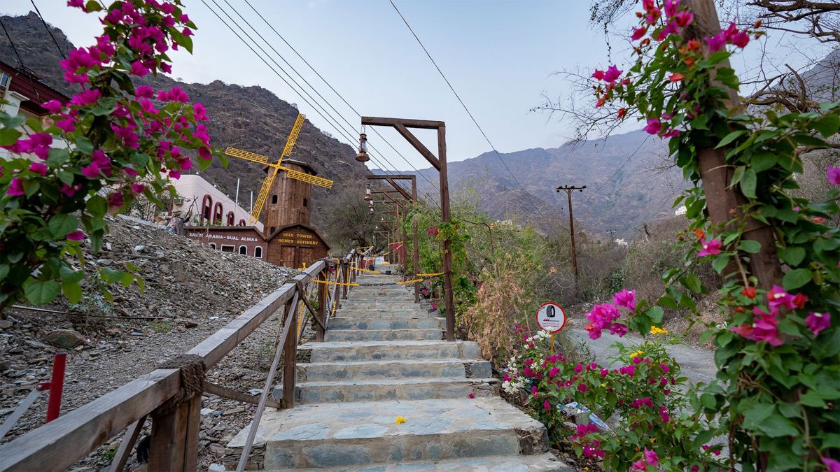
Also known as the Honey Cottage or Kokh Al-Asal, this hilltop wooden cottage in Al Batilah — just minutes from Rijal Almaa — began life as a beekeeper's family home before becoming one of Asir's most photographed stops. Local beekeepers here still practice transhumant beekeeping, moving hives seasonally between the cool Sarawat highlands and the warmer Tihama plain to follow the flowering seasons, which is why the tasting room pours everything from prized Sidr honey to Talh and mixed wildflower varieties.

The rustic complex — bougainvillea-draped stone stairways, a giant wooden windmill and watermill, and a small honey museum — sits wrapped in the same terraced, cloud-brushed mountains that make the wider Abha and Asir highlands (including nearby Jabal Sawda and Al Soudah) Saudi Arabia's coolest summer escape. A guided walk-through shows the full journey from hive to bottle, ending with free tastings.

Honey Cottage Asir Beekeeping Tradition Rijal Almaa Day Trip Abha Mountains
Bees Tower Honey Refinery entrance sign and wooden windmill tower in Rijal Almaa, Asir Province, Saudi Arabia Stone staircase leading up to the Bees Tower Honey Refinery windmill in Rijal Almaa, framed by bougainvillea flowers, Asir Province, Saudi Arabia Wooden windmill tower of the Bees Tower Honey Refinery against the Asir Mountains, Rijal Almaa, Saudi Arabia
Bees Tower Honey Refinery, Rijal Almaa
Honey Refinery at a glance
Location
Al Batilah, adjacent to Rijal Almaa, Asir Province
General info
Converted family home; honey museum, tastings of Sidr, Talh & wildflower honey
Nearest big city
Abha, roughly 45–50 km east
Nearest airport
Abha International Airport (AHB)